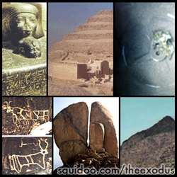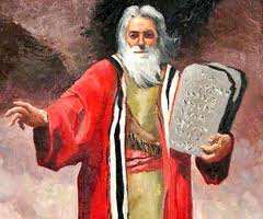
Who was Moses?. . . .
.
Evidence
of Joseph and Moses in Egypt, Moses flees Egypt to Midian then returns to free
the Israelite Slaves.
From Rameses to the Red Sea, crossing it on dry land,
Chariot Wheels found,
encampments in Saudi Arabia, Mount Sinai in Arabia,
Altars, tent circles,
Elijah's cave and more discoveries proving that the Exodus
not only happened,
but happened in a land that is mostly unoccupied even to this
day.
Not a whole lot of people live in these areas and therefore remain
preserved even to this date!
Moses fled to Midian, where is Midian? We
have scripture telling us where Mount Sinai is:
"... is mount Sinai in
Arabia..." (Galatians 4:25).
Bible maps have always questioned the Exodus
route and Mt. Sinai, but with no evidence.
If you look on Map
1 you can see where the old map states where Midian was, in Arabia
(Saudi).
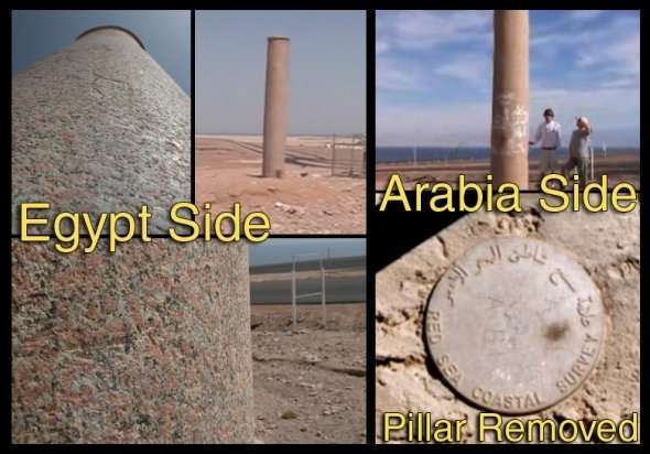
About
3,000 years ago someone put up pillars at the site marking the place of the
crossing.
It was King Solomon's pillars, he was very aware of the site and it
says it in the bible here:
"In that day there will be an altar to the LORD in
the midst of the land of Egypt,
and a pillar to the LORD near its
border." Isaiah
19:19.
You can see the shadow on the Egyptian Side Here:
28°58'11.58"N -
34°38'32.86"E
The pillar on the Saudi side was removed after Ron Wyatt showed
the authorities where it was.
There is a place marker there set in concrete.
There were inscriptions on that pillar that said:
Pharoah, Mizraim (Egypt),
Moses, death, water, Yahweh, Solomon, Edom
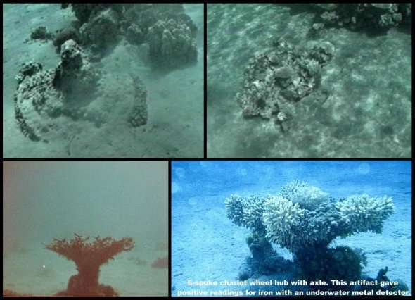
Chariot Wheels and Axles. The Lord caused the Egyptians wheels to come off,
confused
them and then covered all the host of Pharaoh with the waters.
More than 600
chariots, wheels, army gear, weapons, horses and men sunk.
Coral has grown on
these items so they remain preserved.
The wood dissolved, but as the coral grows
the shapes remain the same.
The area has scattered spots of coral,
chariot
wheels preserved, bones, horse hooves, chariot boxes
- at both sides of the
crossing.

This
golden chariot wheel was found at the crossing at Nuweiba.
It was gold
plated 4 spoked, so fragile because the wood had dissolved.
Coral will not grow
on gold and the gold itself preserved this wheel.
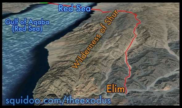
From
the Red Sea they traveled south for three days into the Wilderness of
Shur (Etham).
With no water for 3 days, they found water at Marah.
These
waters were bitter and Moses made sweet with a tree.
Then they come to
Elim which had 12 springs and 70 palm trees and camped there.
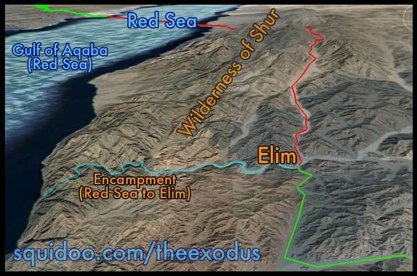
From
camping by the Red Sea, Ron believed they took the route south
because of the
fierce Amalekites (descendants of Esau's grandson, Amalek).
If they had taken
the main wadi straight across to Rephidim,
they would be out in plain view and
vulnerable on all sides.
They refilled their water at Elim before leaving.
The
Israelites did not go to Al-Bad at this time,
because Jethro later brought
Moses's wife and children to Moses
after they were at Rephidim.
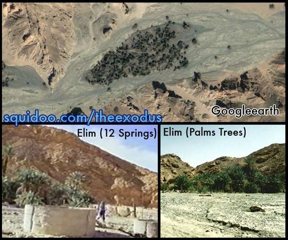
In
the photo above you can see many palm trees on google earth
here: 28°34'12.00"N
- 34°50'8.10"E -
The two bottom photos are of the actual wells themselves here
at this location.
(Dophkah and Alush in between stops)

Red: Red Sea to Elim (Including
Marah).
Teal: Elim Camp and Red Sea
Camp.
Green: Elim to Dophkah.
Pink:
Dophkah to Alush.
Yellow: Alush to Rephidim (near
Mount Horeb).
Blue: Rephidim to Mount
Sinai Camp.
This is my version of Ron's Map based on his description.
(It's very close, but may not be perfect. Can't be sure where Dophkah and Alush
is.)
See Map 6 for Ron's map.
"And
they removed from the Red sea, and encamped in the wilderness of Sin."
Numbers
33:11, Exodus 16:1.
They went through a wadi below Elim. It was the south
side of the mountains that extend west to east (see green line) This supposedly
shielded them to the north by 2 long mountains meeting the wadi on each side.
One mountain is from the Wadi Afal to the Red Sea and the other is the Jebel el
Lawz range from the Wadi Afal to the Mount Sinai. They were safer from attacking
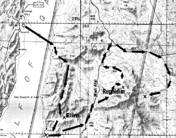
forces. They headed east and come to north/south wadi called Wadi Afal.
In Numbers 33 Moses wrote all their journeys. They encamp at Dophkah and Alush
before reaching Rephidim. There are no clues to these locations except the
meaning of the words. Dophkah means "cattle driving" which years earlier, Moses
had his flocks in this Wadi Afal. Which he would lead his flock from (present
day) Al-Bad of Jethro's home to Mt. Sinai where he heard the Lord speak in a
burning bush. Alush (Aluwsh aw-loosh) means "place in the desert".
(~ All
this information is in greater detail from Ron Wyatt's own accounts on various
websites.)
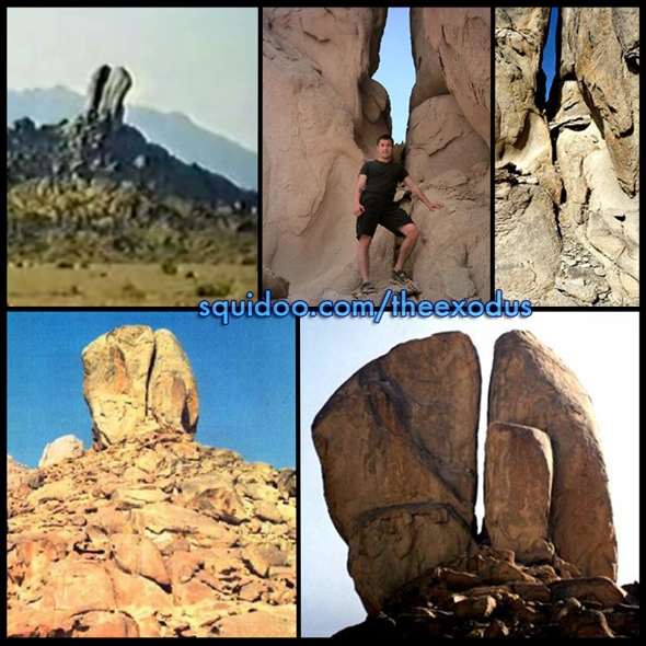
This
5 story high split rock is located on the west side of Jebel el Lawz. Identified
as being the Rock at Horeb, the same rock at Rephidim that the water flowed
from. Googleearth: 28°43'25.72"N - 35°14'18.97"E. The mount Horeb is near Mt.
Sinai.
At Rephidim they complained of a lack of water. This is where
Moses struck the rock near Mt. Horeb and obtained a gushing of water (Exodus
17:1-7; 19:2). Moses named the place "Meribah," or strife. There was also a
clash with Bedouin Amelekites. Aaron and Hur supported Moses' hands in prayer
while Joshua secured a great victory (Joshua 17:8-16).

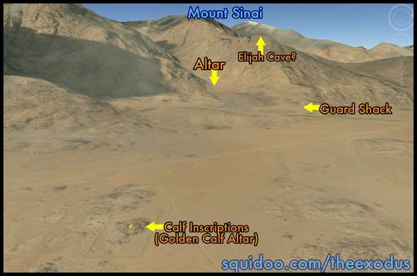
You can also see more detail here: Real Mount Sinai Found! http://www.squidoo.com/mountsinai You'll see the Sacrifice Altar, 'Gold' Calf Altar, Elijah's Cave, Saudi Guard Fence, Tent Circles and more evidence! -- This is seen on googleearth at: 28.5851° Latitude - 35.3534° Longitude
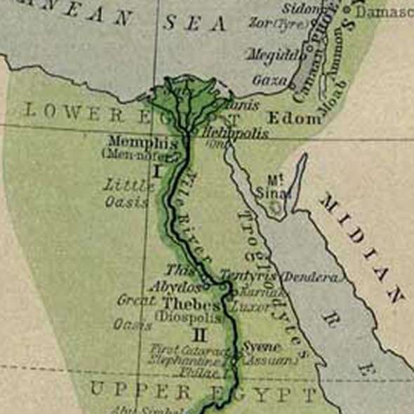
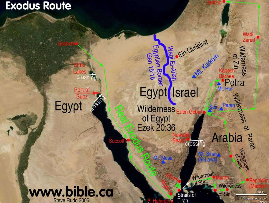
An old map showing where Midian is located, in Saudi Arabia. Also showing where Egypt proper is shown in dark green. Light green is also land patrolled by Egypt. In the bible it says they left Egypt that same day, meaning Egypt proper in dark green. Also notice the wrong location of Mt. Sinai, it's NOT in the Sinai Peninsula, but to the east across the Red Sea, in Saudi Arabia (where it says "Midian").
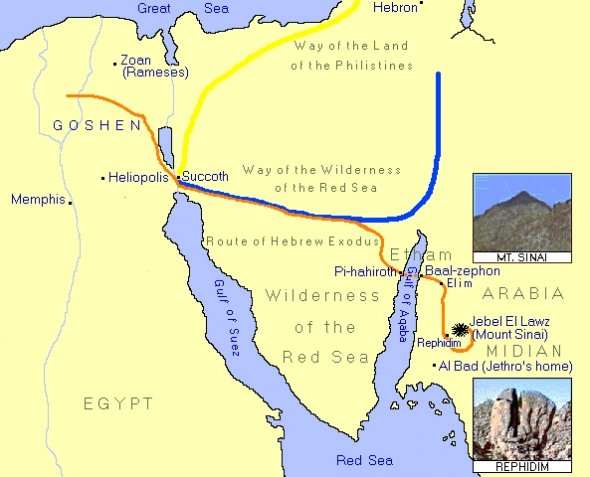
The orange line is the closest to Ron's route, but is not exact. Leaving out a few stops and Ron's route goes the opposite way around to Mt. Sinai from Rephidim. (See Map 4 and 6). Source Unknown.

Another
map I did to highlight the specific areas mentioned in the bible. This is not
the traditional route in the bibles.
More detail of Succoth to Etham
route: Red Sea
Crossing Truth.
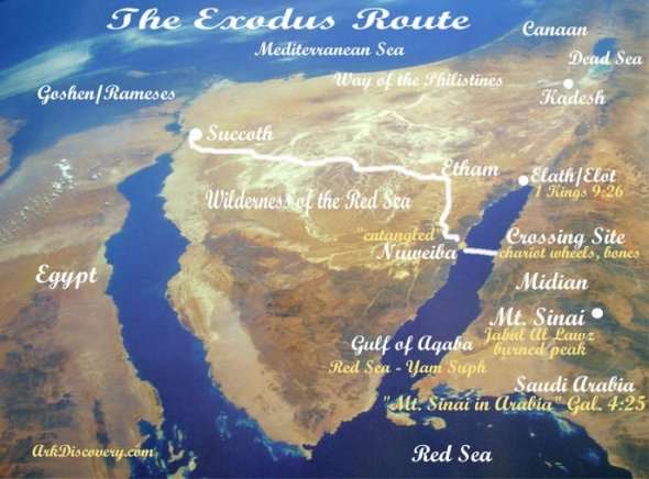
Once
they reached the Red Sea (Gulf of Aqaba) they crossed the Red Sea at Nuweiba
Beach into Arabia. Making their journey through Arabia to Elim, to the Rock at
Horeb (Rephidim) and finally to Mount Sinai (Jebel el Lawz)
Image: http://www.wyattmuseum.com/. Images used with permission. CC All rights reserved. - Ron Wyatt's map.
The Exodus Route: The Route from the Red Sea to Mount Sinai

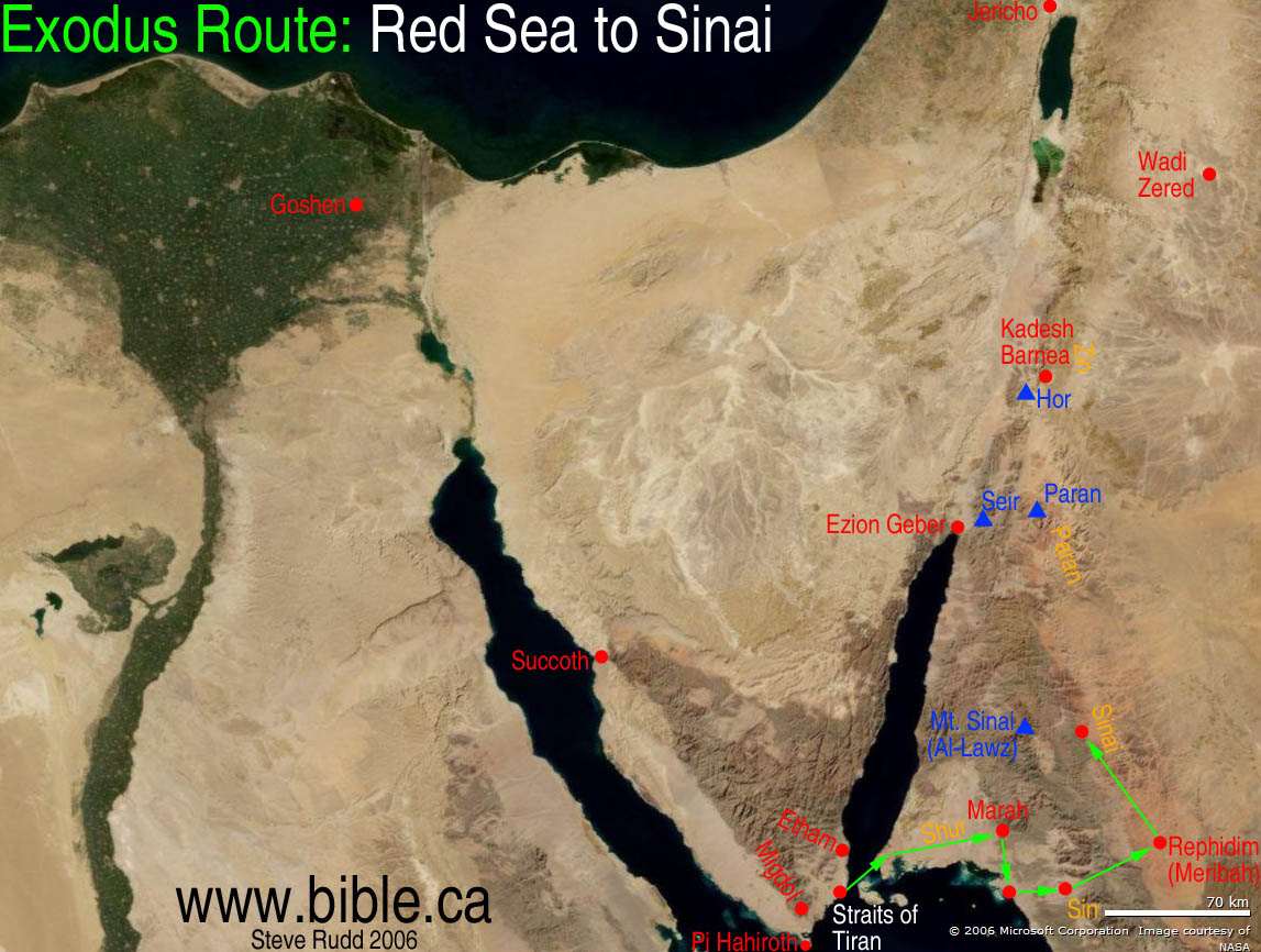
The 10 stops to Mt. Sinai
![]() Wilderness
of Shur
Wilderness
of Shur
![]() Marah
Marah
![]() Elim
Elim
![]() Red
Sea Camp
Red
Sea Camp
![]() Wilderness
of Sin
Wilderness
of Sin
![]() Dophkah
Dophkah
![]() Alush
Alush
![]() Rephidim
(Meribah)
Rephidim
(Meribah)
![]() Wilderness
of Sinai
Wilderness
of Sinai
![]() Mt.
Sinai
Mt.
Sinai
Introduction:
The Exodus Route: The Route from the Red Sea to Mount Sinai
Introduction:
After crossing the Red Sea at the Straits of Tiran, Israel entered the Wilderness of Shur. The Wilderness of Shur is the home turf of both the Ishmaelites and the Midianites and is one of the few places of the 50 exodus locations we know for sure. This also places Mt. Sinai in modern Saudi Arabia.
A. Overview of distances and travel times:
After crossing the Red Sea, the daily rate of travel slowed down a bit. We would expect this, since they did not fear Egypt any more. They traveled each day, except for 7 days in the Wilderness of Sin to be introduced for the first time to the weekly Sabbath and the first giving of Manna. The only other place they stopped was two days at Rephidim (Meribah) when the Amalekites attacked one stop before reaching Mt. Sinai. More details: Travel times, distances, days of the week
|
Trip |
Distance |
Total days |
Camp days |
Travel days |
Daily rate of travel |
|
Goshen to Sinai |
750 km |
45 |
17 |
28 |
27 km/day |
|
Goshen to Red Sea |
490 km |
25 |
8 |
17 |
29 km/day |
|
Red Sea to Sinai |
260 km |
20 |
9 |
11 |
23 km/day |
B. Calculating the days of the week between the Red Sea and Mt. Sinai:
We believe with some level of confidence, that we have enough information to actually calculate the days of the week for the journey between the Red Sea and Mt. Sinai. Jewish tradition (recent, not ancient) states that the giving of the Law on Mt. Sinai was given on Pentecost. We know they departed Goshen on passover (Nissan 14) and the Bible says they arrived at Sinai in 44 days. They were then told to prepare themselves for three days when God would "dawn from Edom upon Sinai". Although we cannot trace this Jewish tradition very far back in history, it is very likely correct. So using this time table, we can reverse the journey and decipher the days of the week until we reach the crossing at the Red Sea. Pentecost always falls on a Sunday. Three days in wilderness of Shur after crossing the Red Sea, (Exodus 15:22) and two more days for Elim and the camp at the sea. (Num 33:10-11). More details: Travel times, distances, days of the week
|
|
Bible texts |
Day # from Red Sea |
week day |
distance from last stop |
|
Crossing Red sea: |
|
0 |
Sunday |
19 km |
|
bitter waters: Exodus 15:22-23; Num 33:8; Luke 13:32 |
3 |
Mon - Wed |
67 km |
|
|
12 springs, 70 palms |
4 |
Thursday |
15 km |
|
|
|
5 |
Friday |
18 km |
|
|
Exodus 16:1 |
6-14 |
Saturday - Sunday Manna came on Sunday, day 7 |
20 km |
|
|
|
15 |
Monday |
24 km |
|
|
|
16 |
Tuesday |
17 km |
|
|
Rephidim (Meribah) Fought Amalekites, Jethro's council) |
Exodus 17:1-9; 18:27 |
17-19 |
Wednesday- Thursday |
30 km |
|
Exodus 19 |
20-22 |
Friday |
38 km |
|
|
God dawns from Mt Seir upon Mt. Sinai |
|
22 |
Pentecost Sunday |
20 km walk from camp to foot of Mt. Sinai |